Hurricane Maria sweeps across Puerto Rico with destructive winds and tremendous rainfall
By Jason Samenow September 20 at 11:05 AM

Hurricane Maria made landfall early Sept. 20 in the southeast coastal town of Yabucoa as a Category 4 storm. It's one the strongest hurricanes to ever hit Puerto Rico. (The Washington Post)
(This article, originally published Tuesday, was updated at 11:05 a.m. Wednesday to reflect the latest conditions in Puerto Rico and the National Hurricane Center advisories.)
Extremely dangerous Hurricane Maria plowed across Puerto Rico Wednesday morning, inflicting a disastrous combination of destructive winds, tremendous rainfall and coastal inundation from surging ocean waters.
The storm slammed ashore near Yabucoa, Puerto Rico at 6:15 a.m. Wednesday as a Category 4 hurricane with 155 mph winds. It is the first Category 4 storm to directly strike the island since 1932.
“This is going to impact all of Puerto Rico with a force and violence that we haven’t seen for several generations,” Puerto Rican Gov. Ricardo Rosselló told the Associated Press. “We’re going to lose a lot of infrastructure in Puerto Rico. We’re going to have to rebuild.”
Eric Blake, a forecaster at the National Hurricane Center, tweeted Maria is the third Category 4 to strike the U.S. in the same season, following Harvey and Irma, which is “unprecedented in the modern era“.
The latest on Maria
At 11 a.m., Maria was positioned 25 miles west of San Juan, which reported sustained winds to 86 mph gusting to 110 mph around 7:30 a.m. before the wind sensor stopped transmitting data. The storm was churning to the northwest at 13 mph and should emerge off the coast of Puerto Rico by midday, but heavy rain and strong winds are likely to continue for many hours thereafter.
While winds continued to howl, inland rain was emerging as the most severe hazard as Wednesday morning wore on. Rivers on the island were rapidly rising, some reaching record levels in a matter of hours.
At 11 a.m., 11 of 27 river gauges on Puerto Rico were reporting “major flooding”.
The National Weather Service in San Juan reported incrediblerainfall rates up to 5 to 7 inches per hour.
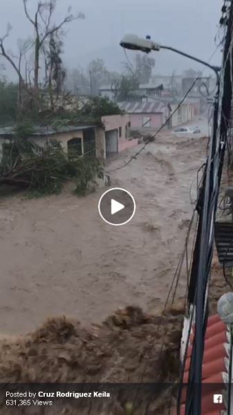
Estimated rainfall totals in eastern Puerto Rico reached over 20 inches. A citizen weather observer in Trujillo Alto, just south of San Juan, reported 15.43 inches in the 24 hours ending at 7:40 a.m.
 Radar-estimated rainfall in Puerto Rico through 10 a.m. Wednesday. (National Weather Service)
As the storm made landfall early Wednesday morning along the southeast coast of Puerto Rico, a National Ocean Service tide gauge at Yabucoa Harbor, Puerto Rico, reported a rise in water 5.3 feet above the normal high tide.
Wind reports became scarce by 8 a.m. as wind sensors and/or their transmission signals failed, but numerous locations clocked gusts over 110 mph.
In the hours leading up to and following landfall, the storm’s peak winds estimated by the National Hurricane Center had decreased some, from 175 to 140 mph, but it remained a powerful Category 4.
Effects in St. Croix
Early Wednesday morning, sustained winds reached 106 mph and gusts were reported up to 137 mph in St. Croix. Between 10 and 11 p.m. Tuesday, St. Croix’s airport on the southwest part of the island reported gusts up to 92 mph before the wind sensor stopped reporting.
While St. Croix was hard hit, the storm’s inner eyewall containing its most violent winds just missed to the south – sparing the island the worst of its fury.
The forecast
While the core of Maria will progress offshore by Wednesday afternoon, Puerto Rico can expect extreme torrential rain and strong winds well into the day Wednesday, perhaps into the evening.
 (National Hurricane Center)
The effects forecast by the National Weather Service over Puerto Rico and the U.S. Virgin Islands are dire, and its warning statement carries an apocalyptic tone.
It says to expect “catastrophic damage” from winds, including “structural damage to sturdy buildings, some with complete roof and wall failures.” It warns that “severe injury is possible in less than a strong structure” and that “locations may be uninhabitable for weeks or months”
It also predicts rainfall amounts of 12 to 18 inches, with isolated totals exceeding 25 inches. The Hurricane Center had warned that the rain may “prompt numerous evacuations and rescues” and “enter numerous structures within multiple communities,” adding that streets and parking lots may “become rivers of raging water” and warns some structures will become “uninhabitable or washed away.”
Along the coast, the Weather Service describes”extensive impacts” from a “life-threatening” storm surge at the coast, reaching 6 to 9 feet above normally dry land. The highest storm surge is likely to occur just north and northeast of where the center makes landfall, which could target southeast Puerto Rico.
In the areas hit hardest by storm surge, the Weather Service describes these effects: “Large areas of deep inundation with storm surge flooding accentuated by battering waves. Structural damage to buildings, with several washing away. Damage compounded by floating debris. Locations may be uninhabitable for an extended period.”
Link: National Weather Service Local Hurricane Statement for Puerto Rico and the U.S. Virgin Islands
The projected storm track is such that the most severe conditions may target St. Croix and southeast Puerto Rico. But the storm is expansive enough that small wobbles could bring devastating effects farther to the north and west, including over the same areas hardest hit by Hurricane Irma, such as St. Thomas and St. John in the U.S. Virgin Islands and the entirety of the British Virgin Islands. And even if these islands remain north of the storm’s core, a dangerous storm surge of up to 7 to 11 feet above normally dry land is possible.
Puerto Rico is very vulnerable to hurricanes, but one has not made landfall there since Georges in 1998. It just missed the worst of Irma, which scraped along its north shore, but an estimated 1 million people lost electricity because of its fragile power infrastructure. Before Irma struck, officials warned some areas could be without power for months.
Just one Category 5 hurricane has hit Puerto Rico in recorded history, back in 1928. The last time a Category 4 storm struck the island was in 1932.
[Puerto Rico has a long history with tropical storms. None of them were like Hurricane Maria.]
Effects on the Dominican Republic, Turks and Caicos and Southeast Bahamas
By Wednesday night and through Thursday, the storm should be exiting Puerto Rico and is forecast to parallel the north shore of the Dominican Republic — also hard hit by Irma. It has been placed under a hurricane warning.
Early on Friday, the hurricane is expected to come close to the Turks and Caicos and southeast Bahamas, which were also ravaged by Irma. They are also under a hurricane warning.
U.S. effects
After the storm passes the Southeast Bahamas, some models suggest it could find an escape route out to sea, remaining offshore from the East Coast, but it is way too early to sound the all-clear.

Group of simulations from American (blue) and European (red) computer models from early Wednesday for Hurricane Maria. Each color strand represents a different model simulation with slight tweaks to initial conditions. Note that the strands are clustered together where the forecast track is most confident but they diverge where the course of the storm is less certain. The bold red line is the average of all of the European model simulations, while the blue is the average of all the American model simulations.(StormVistaWxModels.com)Hurricane Jose may help in keeping Maria away from the U.S. mainland by drawing it to the northeast. However, if Jose weakens too quickly, Maria could drift closer to the U.S. coast by the middle of next week.
Even if Maria remains just offshore along the East Coast, dangerous surf and rip currents are likely.
Maria’s place in history and this hurricane season in perspective
Maria’s landfall pressure of 914 millibars in Puerto Rico Wednesday morning was the third lowest on a record a hurricane striking the U.S.. The lower the pressure the stronger the storm.
On Tuesday evening, Maria’s pressure dropped to 909 millibars, ranking among the 10 lowest in recorded history in the Atlantic.
Its maximum sustained winds, which reached 175 mph, alsoranked among the strongest Atlantic hurricanes on record.
As the storm neared peak intensity Tuesday evening, Michael Brennan, a Hurricane Center forecaster tweeted: “Starting to run out of adjectives for #Maria. Horrifying.”
At 9:35 p.m. Monday, Maria became the the first Category 5 storm to strike Dominica in recorded history, leaving behind widespread destruction.
[‘We have lost all what money can buy’: Hurricane Maria devastates Dominica]
In just 18 hours Monday, the storm strengthened from a minimal Category 1 storm to a Category 5 monster. Its pressure dropped 52 millibars in 18 hours, “one of the fastest deepening rates on record behind Ike, Rita, Gilbert, & Wilma,” tweeted Tomer Burg, at atmospheric science graduate student at SUNY-Albany.
Maria is the latest powerhouse storm in what has become a hyperactive hurricane season.
“2017 joins 1932, 1933, 1961, 2005, and 2007 as only years with multiple Cat 5s,” tweeted MDA Federal, a meteorological consulting firm.
With Maria, the 2017 hurricane season has already featured four Category 4 or stronger storms; this has only happened four previous times by Sept. 18.
Hurricane Jose
 (NOAA)
While Maria is the far more dangerous storm, Jose is a strong tropical storm with 70 mph winds. Positioned 150 miles south of Nantucket, Mass. at 5 a.m., it’s drifting northeast at 8 mph.
Tropical storm warnings cover the coast eastern Massachusetts, where peak wind gusts could reach 65 mph on Wednesday along with 1 to 4 inches of rain. These winds could cause scattered power outages.
 (National Hurricane Center)
Along much of the Northeast coast, minor to moderate coastal flooding is possible as the storm pushes ocean water ashore — up to 1 to 2 feet above normally dry land at high tide. All along these shores, dangerous surf and rip currents are expected.
The National Weather Service says that in coastal eastern Massachusetts, 15 to 20-foot waves could pound exposed beaches, causing severe erosion.
Link: Tropical storm impact statement from National Weather Service for eastern New England
(The Washington Post)